Saturday, June 13, 2009

Bamyan, Band-i-Amir, and Panjshir Valley

This past weekend in Afghanistan, our Chief of Party organized the most amazing helicopter fly over of Bamiyan, Band-i-Amir, and the Panjshir Valley. Bamyan is approximately 240 kilometers northwest of Kabul and is situated on the ancient Silk Road between the Hindu Kush and the Koh-i-Baba mountain ranges. Bamyan town served as a crossroads between the East and West, and all trade between the Middle East and China passed through here. It is most famous for the two giant Buddhas that stood for almost two millennia until dynamited to rubble in 2001 by the Taliban.


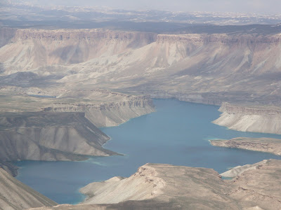
After getting over the excitement of finally having seen the Bamyan ruins, without any warning, we begin passing over the most gorgeous, rich blue bodies of water that I have ever laid eyes on- the lakes of Band-i-Amir. The sight was unreal, and even now, when I look at my photographs, I’m still in disbelief of the beauty. The lakes are formed by underwater mineral springs that give the lakes their amazing colors. Whether I’m looking at the real thing or one of my photos, it only looks like it could be an oil painting. It’s that stunning.


On our way back to Kabul, we were treated with a fly over of Panjshir Valley, where the Great Masood defeated both the Russians and the Taliban. No one has ever been able to take over the valley since. Many Afghans often spend their Fridays off in the valley over picnics by the flowing, fresh mountain river.


Add Image


East + West = Identity Crisis

April 8, 2009. Istanbul really is a world of its own, and there’s nothing quite like it. It is surrounded by water on every side, including right down the middle by the Bosphorus that separates European Istanbul from the Asian side. This makes Istanbul the only metropolis in the world to be situated on two continents. History imposes itself on you, and one cannot help but gaze at the remains of the Ottoman Empire and not be struck with awe by its architectural and cultural feats.

We spent roughly one week in Istanbul before exploring further down Turkey’s western coast to Selcuk, Ephesus, and Pamukkale. While some inhabitants claimed to be European and boasted of different sites being the longest/highest/largest blah blah blah in Europe, we were often baffled because after all, Turkey is still considered Central Asia, and we certainly were not in Europe. Others quite proudly flaunted and discussed their strong Asian heritage and loved to boast of Rumi’s strong and long presence in Turkey after having left the Balkh province of northern Afghanistan. And, most peculiar was how much more modern and Western the Asian side of Istanbul turned out to be in comparison to the so-called European side with its skyline studded with mosques and minarets. Since most Istanbullus are desperate for inclusion into the European Union, it seemed very apparent that there was some level of denial among the younger generation over their ‘continentality,’ lending to a bit of an identity crisis. That aside, Istanbul has now become one of my favorite cities in the world with the perfect balance of it all. As a renowned author once said, “If one had but a single glance to give the world, one should gaze on Istanbul.”


Pamukkale is an incredibly unusual natural wonder of the world, and I figured it was appropriate to give a little bit of background before posting photos. The word means cotton castle in Turkish and is a natural site in southwestern Turkey in the Denizli Province. The ancient city of Hierapolis is situated just above Pamukkale. Quoted from Wikipedia: “The tectonic movements that took place in the fault depressions of the Menderes river basin triggered frequent earthquakes and gave rise to the emergence of a number of very hot springs. The water from one of these springs, with its large mineral content—chalk in particular—created Pamukkale. Apart from some radioactive material, the water contains large amounts of hydrogen carbonate and calcium, which leads to the precipitation of calcium bi-carbonate. In the course of time, some sources dried up because of earthquakes, while new ones arose around it. The effect of this natural phenomenon has left thick, white layers of limestone and travertine cascading down the mountain slope, resembling a frozen waterfall.”


Friday, June 12, 2009

Return from the Ottoman Empire

April 7, 2009. I’m still in disbelief as to how quickly time is flying. Ten months have passed since I came to Kabul on assignment, and I’ve just returned from a most amazing R&R in Turkey with my very good friends, Vivek and Sherin from Washington, DC. Nearly every moment of our two weeks spent primarily along the Western coastline, we indulged in the rich history, culture, and dynamism of life in the former great Ottoman Empire.

I arrived a few days earlier than Vivek and Sherin and decided to fly directly from Istanbul to Kayseri to visit the famous Cappadocia region, renowned for its unusual lunar landscape. I stayed in one of its many cave hotels, something very unique to its tourism industry. On my way from the airport, I met another lone Colombian traveler who was also coincidentally staying at the same hotel. We were both warmly met at the Gamirasu Cave Hotel by Hamida, one of the friendliest, warmest individuals I’ve come across in a long time. Before hitting the sack after a full day’s travel, I played translator between the Colombian and Hamida, and I have to admit that I was pleasantly surprised by the amount of Spanish that suddenly came to my assistance in that moment.

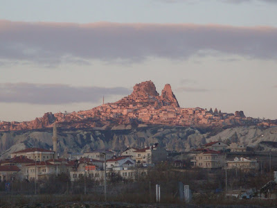
The following morning, I began my tour with a young group of Americans to Kaymakli Underground City, one of several underground settlements. We followed that with some hiking in Soganli Valley, which is full of rock cut churches rich with frescoes, surrounded by table top mountains. The landscape is incredibly unique in that it is largely underlain by sedimentary rocks formed in lakes and streams and ignimbrite deposits erupted from ancient volcanoes approximately three to nine million years ago. The rocks of Cappadocia eroded into hundreds of pillars and minaret-like forms. The volcanic deposits are soft rocks that people have carved out to form some of the most amazing houses, churches and monasteries-cum-madrassas, full of frescoes painted with very resilient vegetable dyes. We visited a newly discovered archaeological excavation site of mosaic houses in Sahinefende-Sobessos before heading to Cemil, an old Turkish town settled by the Selcuk Turks at one point. After finishing off the tour in the small Greek town of Mustafapasa, I arranged to observe a Sufi prayer session.

On my second and last day in Cappadocia, I was the lone traveler with our tour guide from yesterday, Mustafa, and our driver whom we called Hajji Sahib, as he had just returned from Hajj in Mecca. The day started at 5:00 am to sail over the lunar landscape in a hot air balloon, which I highly recommend to anyone planning to make this visit. The views of the rock formations in Devrent Valley and Uchisar are breathtaking! After a good, hot breakfast, we visited the Pasabag fairy chimneys, “where the voice of wind mixes with the song of fairies.” We stopped for lunch in Avanos, known for its terra cotta work of art dating as far back as 3000 BC. The pottery is spectacular, and though I’m sure very over-priced, I couldn’t resist buying enough of it to require a shipment back to the States, only to be stored with the rest of my worldly possessions at Amma and Appa’s house.

Vivek and Sherin had, by now, arrived in Istanbul, and it was time to make my way back to the city where East truly meets West.






Travels in Southern Africa

May 6, 2008. It’s been nearly six months since I first arrived in Swaziland, and I can’t believe it’s now nearly time to start packing up. I’ve made some of the best friends while on assignment here, and we managed to squeeze in some traveling in between work. This past weekend, we scratched the surface of Durban, home to generations of South Indian Tamil immigrants who were brought to South Africa as indentured laborers in the 1860s to work the sugar cane plantations under the leadership of a British governor. Most of our time was spent eating in sushi and Indian restaurants or on the beach by the ocean, which was quite a luxury since all of us are from coastal cities but have been living in Swaziland, which is a land-locked country. We wrapped up our last day at the Indian market, near Mahatma Gandhi Avenue, shopping for unique, African-influenced Ganesha statues and chappals.


A couple of weeks before Durban, some girlfriends and I made a trip to Cape Town for a long weekend, and it is, by far, one of the most topographically eclectic cities I have ever visited. We spent our first evening riding a cable car up Table Mountain and enjoying the amazing views of the city, ocean, and mountains over a bottle of white wine. We spent the following day at the V&A Waterfront, and the Cape of Good Hope, where the Indian and Atlantic Oceans meet. As we walked up to Cape Point, I heard someone shouting my name with a French accent and coincidentally ran into an individual who is working for the European Union who I had met in Swaziland one morning! We wrapped up that evening at a Thai restaurant after visiting the African penguins at the Boulder Beach penguin colony in Simon’s Town. For those of us visiting Cape Town for the very first time, we managed to get tickets to Robben Island after waiting in a queue for two mornings for on the day sales. The Island is located in Table Bay, seven kilometers off the coast of Cape Town. It was here that former South African President Nelson Mandela, alongside many other political prisoners, spent decades imprisoned during Apartheid. We spent our last full day exploring the many famous wineries that Cape Town is renowned for.


In between it all, we decided to make the six hour drive south of Swaziland to Blyde River Canyon in Mpumalanga, which forms the northern escarpment of the Drakensberg Mountains in South Africa. One of my good friends, Liz, had a colleague who had just moved to the nearby town of Graskop, so it was a good opportunity for a quick, but relaxing visit. The Draks is a 200 kilometer long mountainous landscape that was named Ukhalamba by the Zulu people and the Dragon’s Mountains by the Dutch Voortrekkers and serves as a natural barrier between KwaZulu-Natal and the Kingdom of Lesotho. Ostensibly, it was the Draks that inspired Tolkien when he chose the terrain on which the Lord of the Rings series takes place. Blyde River Canyon is apparently the third largest canyon in the world after the Grand Canyon in the U.S. and Fish River Canyon in Namibia. The highlight of the trip was the Three Rondavels, and along the route, we visited God’s Window, the Pinnacle, and Bourke’s Luck Potholes.